Updated: 18 February 2026
This article is an attempt to summarise the events of the last few weeks in connection with the floods in Sumatra and to gather as much information as possible. The situation remains critical and unclear. Up-to-date information is scarce. This article will be continuously updated.
If you have any current information, please contact us and we will publish it here.
Flood in Sumatra
ToggleLatest news from the affected regions
One month has passed and the situation for the mayority of affected places is still desastrous. People sleep in tents or temporary shelters. The amounts of logs that have been washed into villages is extreme – removing this alone will takes very long.
As of updating this article President Prabowo Subianto has refused foreign aid, insisting the situation is “under control”. Many people believe, this is to hide the actual extent of the logging industry which was a mayor factor in causing the floods.
- Several areas in Central Tapanuli Regency were again hit by floods due to heavy rain that fell since 16 February 2026.
- Indonesia is fast-tracking permanent homes and expanding temporary shelters for residents displaced by disasters. The government is also preparing land to help residents move from temporary shelters to new homes.
- Of the 52 districts/cities affected by the disaster, 23 regions are still in a state of emergency response.
- Some important roads have been restored to bring groceries and logistics into the villages.
- In Aceh many still do not have access to clean water, food, electricity and medical supplies.
- The Energy Ministry sent 1,000 generators and 3,000 stoves.
- It is estimated that 22 villages have been completely destroyed.
- In Ketambe the situation is somewhat improved – they have temporary road access, electricity and phone towers are all working. Excavators have spent several days working to stabilise the river further from the road to avoid continued erosion. Trekking will continue in January.
- Although the floodwaters are receding in most areas, the aftermath is still ongoing for millions of people in the affected areas. Aid is only arriving slowly, and many areas remain cut off and/or covered in mud. Residents of the affected villages still have limited access to food and water.
- The Tapanuli region is currently only accessible via Sibolga and Singkil.
- The road from Parapat to Sibolga is now accessible via the Rampa-Poriaha route. The main route has been completely cut off by a landslide and remains impassable.
- Tarutung is completely destroyed.
- The route from Lake Toba to Bukittinggi is passable again.
- The road from Padang via Lembah Anai to Bukittinggi is open from 5 pm – 8 am. The government is still working on it, they said it may take until February.
- Anyone travelling from Padang to Bukittinggi must go via Lauik – Solok – Singkarak – Padang Panjang. This journey takes longer, partly because of the traffic jams there.
You can find the latest news in the Sumatra Facebook group, at Antaranews or at Jakarta Post, for example.
How did the flood in Sumatra happen?
At the end of November 2025, Sumatra experienced one of the worst natural disasters in recent years: extreme rainfall, triggered by tropical cyclone Senyar, hit parts of the island with full force.
Combined with persistent monsoon rains, the already delicate balance between landscape, watercourses and vegetation was overwhelmed. Many rivers burst their banks, and mountains and slopes were unable to withstand the masses of water — leading to torrential floods and landslides. More info
Deforestation and unregulated land use further exacerbate the danger: where protective forests are lacking, rainwater can rush into the valley more quickly — significantly increasing the risk and extent of the disaster.
Important to know: Such severe cyclones near the equator are extremely rare — tropical cyclones are usually further away. The combination of global climate change and local interventions in nature and the landscape is likely to have contributed to this exception.
Brief summary
- Since the end of November 2025, floods and landslides on Sumatra have claimed the lives of more than 1,000 people in North Sumatra, West Sumatra and Aceh.
- Damage to roads and bridges has disrupted major transport routes such as the motorway from Medan to Banda Aceh and cut off villages in Agam, Central Tapanuli and other districts from the outside world.
- Major transport hubs such as Kualanamu International Airport in Medan, Minangkabau International Airport in Padang and Sultan Iskandar Muda International Airport in Banda Aceh remain operational, but access roads and bus services may be affected.
- West Sumatra and Aceh have declared a state of emergency until mid-December, while authorities are attempting to control rainfall with cloud seeding.
- Travellers should postpone non-essential overland travel, favour domestic flights, and have flexible plans, insurance and alternative routes ready if they wish to keep Sumatra on their itinerary.
Affected regions — and the current situation
The disaster has affected large parts of Sumatra — the following provinces have been particularly hard hit:
- Southern North Sumatra, including the regions of Sibolga, North Tapanuli, Central Tapanuli, South Tapanuli and Humbang Hasundutan.
- West Sumatra, especially districts such as Padang Pariaman and other mountainous areas, has also been severely affected.
- Aceh — flooding and landslides have also been reported there.
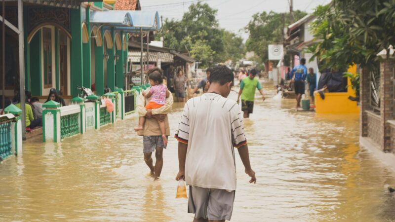
In many regions, entire villages were flooded, houses destroyed, bridges and roads washed away. Communications and power supplies were cut off. In some areas, rescue teams could only be reached by helicopter due to damaged roads. Millions have los their homes.
At least the authorities and rescue services are now working to clear important transport routes. For example, the Tarutung–Padang Sidempuan Road in North Sumatra has been reopened — an important route for supplies and aid deliveries.
Map of the affected regions
You are currently seeing a placeholder content of Snazzymaps. To access the actual content, click on the button below. Please note that data will be passed on to third-party providers.
What does this mean for travellers — and what is the situation for tourist destinations?
Even though the disaster is extensive, not all regions of Sumatra are affected. Based on current information, the following locations are considered accessible at this time:
- Bukit Lawang
- Berastagi
- Lake Toba
- Pulau Weh
- Padang
- Bukittinggi
- Harau Valley
Transportation from Medan Airport is still available for destinations in North Sumatra.
Can you currently visit Sumatra?
Yes — travel to Sumatra is still possible. The floods affected specific regions, not the entire island. Many popular destinations like Bukit Lawang, Pulau Weh, Berastagi or Lake Toba are currently safe and accessible as usual. At the same time, it is important to stay informed about the local situation before and during your trip, remain flexible, and follow advice from local authorities.
For many local people, tourism is the main source of income. When visitors stay away out of general fear, this often has serious consequences for families and small businesses. Responsible travel can therefore also mean continuing to visit where it is safe to do so and consciously supporting local communities.
Travellers should note the following
- Some routes — particularly West Sumatra and the route from Medan to Banda Aceh — are restricted or impassable due to road damage, bridge and infrastructure problems. (Source: The Adept Traveller)
- Petrol mafias throughout North and West Sumatra cause traffic jams at virtually every petrol station.
- There may be delays and shortages of accommodation and supplies — travellers should be flexible and prepared.
- Good travel insurance, contacting local authorities or accommodation providers in advance, patience and sensitivity are important now.
- Be aware of the climate and weather: monitor forecasts, heed warnings — there is still a risk of new mudslides if there is further rainfall.
So anyone currently visiting Bukit Lawang, Berastagi or Lake Toba can travel in principle — but should be aware that the situation in other parts of the island remains dramatic.
Why such cyclones are unusual at the equator
Tropical storms or cyclones such as Senyar are extremely rare near the equator — they usually form further north or south, where sea and air temperatures and Coriolis force provide favourable conditions.
The fact that such a storm has now hit Sumatra highlights the growing importance of climate change and environmental destruction: higher sea temperatures, changing air pressure systems and extreme weather events mean that even regions that were previously “safe” are now at risk.
Added to this are land use problems: deforestation, logging and soil erosion make the land more susceptible to flooding and landslides — protective mechanisms are breaking down. Combined with extreme weather, this creates a dangerous scenario.
For us as travellers and nature lovers, this means greater respect for the environment and landscape — and awareness of how fragile some regions have become.
Donations and support
Anyone who wishes to do so can provide direct support to the victims of the flood disaster. There are various initiatives and aid organisations that are currently urgently providing donations, supplies and reconstruction assistance. We have compiled a list of some of them below.
- Friendship Guesthouse Ketambe – this popular guesthouse in Ketambe has been completely erased. More info
- The NGO HAkA Instagram-Post
- The NGO Children of Sumatra Instagram-Post | Website
- The Swiss NGO Paneco Website
- The Orangutan Project Website
- Rainforest Rescue Website
- Yayasan Konservasi Donation Page
- Katka drives regularly to Aceh with important goods Fundraiser
If you know other NGOs or individuals, pleast contact us.
Conclusion
The flood disaster on Sumatra at the end of November 2025 clearly shows how vulnerable nature and infrastructure are, even in regions that were previously considered relatively safe. The rare Cyclone Senyar, decades of environmental destruction and climate change turned a dramatic weather situation into a humanitarian tragedy.
For travellers: Caution is advised, especially in northern and western Sumatra. Those visiting Bukit Lawang, Berastagi or Lake Toba can travel safely with common sense and good planning. However, solidarity, patience and consideration are required, as well as an awareness that our travels are embedded in a complex network of nature, climate and society.
Photo by Misbahul Aulia on Unsplash